Tweed Valley Tunnel Trail Run 10k
I ran my first ever trail run - and probably my last. Peebles may have had beautiful scenery, but navigating through muddy terrain is unappealing.
This was quickly followed by having to get over a fallen tree. So less of a run, more of an obstacle course.
But I also rather not go through that again. Maybe it would be better in drier conditions, but on the whole, trail running was too high-alert for me.
I had never heard of this, but came across it during a quick Google search before the run.
 |
| This lady don't like mud. |
Why Peebles
While I love that these races take me away for the weekend, I wanted my October run closer to home as I will be traveling to the US at the end of the month.
Peebles checked the boxes for both close and somewhere new. Plus, I was intrigued by the idea of a trail run as I had never done one before, so this presented a new challenge.
The main selling point, though, is that the race has a stretch under an old railway tunnel that they light up in funky colors. So a bit more excitement than the tunnels in Bath.
The journey
I've done trains and planes, but for Peebles, I had the luxury of a car ride. I ran the race with my coworker Tim who very kindly drove us to the race.
No travel mishaps on the way down. Maybe a few on the way back. We'll get to that later.
The run
Muddy hell
The weather when we arrived was overcast, but not rainy, thankfully. However, it had been raining throughout the week. This meant mud. Lots of mud.
 |
| When I was just starting to realize how muddy this was going to be. |
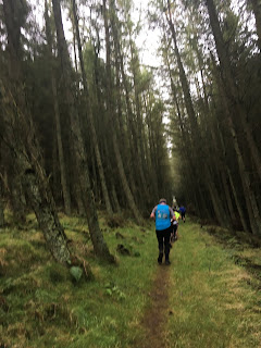
I learned very quickly that muddy running is scary. And slow. I was trying desperately not to slip.
I wasn't even one full song in my playlist in before I turned off my music. It was a matter of safety. I needed to be alert at all times.
Especially since the trails were narrow - people were often trying to pass me, and I needed to hear that.
When Strava told me my first half mile was over 5 minutes, I realized that time didn't matter in this race. Finishing without a broken ankle was top priority.
Photo-worthy stops
One benefit of a trail run - it sure is pretty. The scenery made up for the fear of slipping.
The run started along the River Tweed and then took a sharp uphill climb to the first water station.
The view when I got there was absolutely spectacular. For the first time ever on a race, I decided to stop and take photos. Or run and take very shaky photos.
 |
| Not a bad place for a water stop. |
Running up those hills
Other than stopping for photos, I attempted to run every other part of this race. There were some points where running was just not feasible, though.
The climbs on this route were steep. It made Tenby look flat. The elevation gain was 935 feet.
I was 'running' up all these hills, but I'm not even sure you could call it that.
I was 'running' up all these hills, but I'm not even sure you could call it that.
 |
| It's the 'pretty, but more hills ahead' look. |
There reaches a point of steepness where what you're doing doesn't resemble running anymore. It was more like climbing quickly.
I actually preferred the climbs on this route, though, because they tended to be the least muddy bits. Going downhill in some parts was absolutely terrifying. Tree branches were my friend.
At one point, I had to climb over a ladder to get over a stone wall. You can't run that.
This was quickly followed by having to get over a fallen tree. So less of a run, more of an obstacle course.
 |
| I liked the trees I didn't have to jump over. |
Light tunnel
The last part of the route was through the 600 meter-long Neidpath Tunnel. It's normally pitch black, but they put on lighting effects just for this run.
For this, I turned my music back on. With its disco light feel, I felt tunes were appropriate.
 |
| Running + dark tunnel = terrible photo (but you get the idea). |
This stretch was also over rocks, which were perhaps more stable, but not really a welcome change from the mud.
Accomplished finishers
One final stretch back over the river, and I was finished. Final time was 1:17:15.
 |
| A bridge crossing before the finish. |
When I said at the start of this year I wanted to do each race under an hour, I didn't know I would be doing a trail run. And I didn't realize how much more challenging trail running is.
I also now understand why everyone kept asking me what the grip was like on my sneakers. They weren't trail shoes, but I did get through the race slip-free.
 |
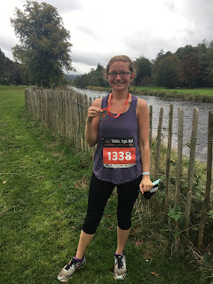
| Slip-free, definitely not mud-free. |
Tim did an amazing job doing the 4k route. He started running recently, and trail running was new to both of us.
Considering the fact that we're both still standing, I'd say we aced it.
 |
| We lived to tell the tale of the trail. |
I think I will stick to pavement.
The Great Polish Map of Scotland
Wanting to get one bit of tourism into this trip, I suggested to Tim we stop on the way back at the Great Polish Map of Scotland.
I had never heard of this, but came across it during a quick Google search before the run.
It's a terrain model of Scotland built by a Polish war veteran in the 1970s. He stayed in the area after having been stationed in the Scottish Borders during WWII.
He built the model to show his appreciation to Scotland for their hospitality over the years.
The ride to get there proved what a lazy passenger I am. I was absolutely no help with directions and there may have been a few wrong turns to get there.
The real offender, though, was Apple Maps, which thinks this map is a few miles north of where it actually is.
But we got there. The map sits on the grounds of a fancy hotel. You cross a bridge with a pretty waterfall in the background to get there.
 |
| Waterfall from the bridge. |
Boy, was this thing massive. My photo does not do it justice.
 |
| Couldn't fit all of Scotland in the picture! |
It's absolutely bizarre to think some guy wanted to build this. But it seemed like a fitting conclusion to my 2nd and final race in Scotland this year.
Next race
It's back to flat and coastal at the bottom of Britain.


Comments
Post a Comment